The short answer
An altimeter is an instrument that tells you how high you are. Almost all of them do it in one of two ways, and the difference matters more than the word does:
Barometric
Measures air pressure and converts it to a height. Needs no signal, no satellites and no network — but it has to be told what pressure counts as your zero, and the weather keeps moving that.
Satellite (GPS/GNSS)
Works out a position in three dimensions and reads the height off it. Needs no setting up — but it is markedly less accurate vertically than horizontally, and it needs a view of the sky.
The instrument in your phone is the first kind. Every iPhone since the iPhone 6 has a barometer in it, which is why an altimeter app can work in a gorge with no reception at all — and why it will read differently tomorrow if the weather changes and nothing resets it.
How a barometric altimeter actually works
Air has weight. Stand at the bottom of the atmosphere and you have the whole column pressing on you; climb, and there is less of it above you, so the pressure falls. That relationship is steady enough near the ground to be useful:
Near sea level, pressure drops by roughly 1 hPa for every 8 metres you climb — about 1 inHg per 1,000 feet. Higher up the air thins out, so the same 1 hPa buys you more height: by 5,000 m it is closer to 15 m.
An altimeter measures the pressure, then runs that relationship backwards to get a height. To do it, it has to assume an atmosphere — the standard one, defined as 1013.25 hPa and 15 °C at sea level, cooling by 6.5 °C per kilometre as you rise. Real air is never exactly that. Every barometric altitude reading is therefore a measurement run through an assumption, and the assumption is where the errors live.
Why it drifts, and what to do about it
Pressure at any fixed point changes with the weather, quite a lot. A deep low passing through can drop it 20 hPa below a calm high — and your altimeter, which cannot tell weather from climbing, will faithfully report that as 160 metres of ascent you never made. Sitting still overnight while a front comes in is enough to move the reading by tens of metres.
The fix is calibration: tell the instrument a height you know, and it works out the pressure that must correspond to it. Do that at a trailhead sign, a summit marker, a station platform, or against sea level pressure from a local forecast. Aviation does the same thing under a different name — a pilot dials the current sea-level pressure (QNH) into the instrument before flying, or 1013.25 when high enough that everyone agrees to share the same fiction.
A good phone altimeter can shortcut this: it can take a GPS or terrain-model height as a starting reference, then let the barometer do the fine work from there. That is the combination worth having — satellites are steady but coarse, pressure is precise but wanders, and each one covers the other's weakness.
How to read an altimeter dial
The classic instrument looks like a clock with three hands, and it is read the same way: each hand counts a different digit. This is the aviation face; a mountaineering altimeter usually has one needle and a simpler scale, and a phone just prints the number.
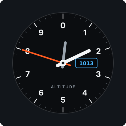
- The long thin hand is hundreds. One full turn is 1,000 — so it is the one that moves visibly while you climb.
- The short fat hand is thousands. One full turn is 10,000.
- The small stubby marker is ten thousands. On a mountain it barely moves at all.
- The window on the side — the Kollsman window — shows the pressure the dial is set to. If that number is wrong, every hand on the face is wrong with it.
Read them in that order, largest first, exactly like reading a clock backwards: ten thousands, thousands, hundreds. The classic mistake is reading the two long-ish hands in the wrong order and being out by a factor of ten — which is why glass cockpits replaced the three-pointer dial with a plain number.
Rule of thumb for the window: set the pressure 1 hPa wrong and the height is about 8 metres wrong — roughly 28 feet. It scales the way you would expect, so being 10 hPa out puts you 80 metres from where the dial claims.
Altimeter or barometer — what is the difference?
Physically, often nothing: the same pressure sensor sits behind both. The difference is the question asked of it. A barometer reports the pressure and expects you to stay put, so that changes mean weather. An altimeter assumes the weather is holding still, so that changes mean you moved.
Both assumptions are half-true, which is exactly why the same instrument can be excellent at telling you that you climbed 340 metres this morning and useless at telling you what altitude you are at in absolute terms without being set first.
What about the altimeter in a watch or a phone?
Same physics, smaller sensor. A modern MEMS pressure sensor resolves changes well under a metre, which is why your phone can notice you walking up a flight of stairs. That sensitivity is real — but it is sensitivity to change, not accuracy about where sea level is, and those are different claims. An app that shows you 1,247 m to the metre without saying how sure it is has confused the two.
What is worth looking for, in a watch or an app:
- Does it show its uncertainty, or just a confident number?
- Can you calibrate it against a known height, in one gesture, without menus?
- Does it separate climbing from descending, and exclude lifts and cable cars?
- Does it keep working with no signal — and keep your day if the app dies?
Want the number for where you are standing, without installing anything?
Check my elevationA note on aviation
Much of what is written about altimeters is written for pilots, and their problem is not quite yours. An aircraft altimeter is about separation — keeping two aeroplanes apart vertically matters more than either of them knowing its true height above the ground, which is why above a certain level everyone sets 1013.25 and flies a shared fiction together. Radar and radio altimeters, which measure the actual distance down to the terrain, are a different instrument again.
On a mountain none of that applies. You want the real height, referenced to sea level, and you want to know how far off it might be.
So: what should you trust?
For where you are right now, in absolute terms: a terrain model, or a barometric altimeter you have just calibrated. For how much you climbed: the barometer, easily — no satellite fix will resolve a 40-metre rise reliably. For anything to the centimetre: nothing on this list, and be suspicious of whatever claims it.
That last point is the whole design of VERT. It reads the barometer, it carries the ± the system actually reports rather than hiding it, and it writes your day to disk as you walk instead of when you remember to press stop.